Chronicle
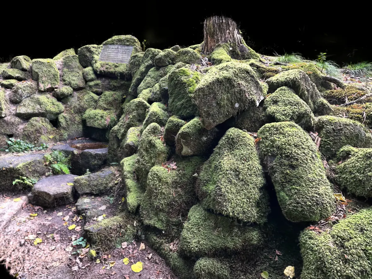
In the woods beside the B 460, the Siegfriedstraße, between Hiltersklingen and Hüttenthal lies the Lindelbrunnen: a spring caught in a round stone basin, reached by a few flat steps and surrounded by a mound of stacked blocks. The state of Hesse lists it as a cultural monument for historical reasons. A bronze plaque on the topmost block says why: according to tradition, Siegfried was slain at this spring, and its name already appears in a description of the boundaries of the Mark Heppenheim.
The second claim can be checked, though not with the plaque’s date. In 773 Charlemagne gave the Mark Heppenheim to Lorsch Abbey. The description of its boundaries is undated; it runs from the Rhine plain over the Felsberg into the Odenwald and tells how the royal envoy Rado marked the Mark off from the Michelstadt forest district with three heaped-up boundary mounds. The third lay at the Lintbrunnen. A charter of mid-August 795, in which Charlemagne confirmed the boundaries after a court session on the Kahlberg near Weschnitz, names it again: Lintbrunno. The editor of the Heppenheim regesta identifies it with today’s Lindelbrunnen. Hence the two dates: 773 on the plaque is the year of the gift, 795 in the monument register, qualified there with an “allegedly”, the year of the charter. One study even moves the undated boundary description into the 11th century. In any case none of the charters survives itself, only their copies in the Lorsch Codex, compiled around 1170 to 1195.
The first claim is worded more carefully, and with reason. In the Nibelungenlied Hagen lures Siegfried into a race to a spring during the hunt and drives a spear into his back as he bends down to drink. Manuscript C, a later reworking of the epic, adds place names: before the Odenwald lies a village called Otenheim, and there the spring still flows — “da vliuzet noch der brunne”. Since then several springs in and around the Odenwald have claimed to be the scene of the murder. The best known is the Siegfriedbrunnen near Gras-Ellenbach, about 3.7 km to the west as the crow flies, whose claim goes back to research from 1844. The same objection applies to both: Worms is about 40 km away, and Siegfried’s body is said to have been carried there that same night. A poem cannot prove a crime scene anyway, at most a place its reviser had in mind.
Little at the Lindelbrunnen is built, and what is built is recent. According to the plaque and the monument register, the Odenwaldklub newly enclosed the spring in 1884, two years after the club was founded; in 1953 it was thoroughly renewed. How much of the 1884 work still stands is not documented. In the scan the basin sits at the foot of a wall of smaller blocks, with flat stepping stones in front; on the right, larger angular blocks are piled into a mound with a tree stump on top. Moss covers almost everything; where it is missing, the stone is reddish. Mossautal lies in the west of the Buntsandstein Odenwald, so red sandstone is likely; it has not been checked on these blocks. Whether they are mortared, the moss hides.
So less is documented at the Lindelbrunnen than the plaque says, and yet something rare: a spring that was written down as a boundary mark more than 1,200 years ago — if the identification holds — and that still gives water today. Here the line from manuscript C can be taken literally, even if it remains open whether it means this spring.
Sources
- Lindelbrunnen — Szene auf superspl.at ↗
- Lindelbrunnen — DenkXweb, Kulturdenkmäler in Hessen, Nr. 11565 ↗
- Lindelbrunnen — Torsten Wondrejz, Regesten der Stadt Heppenheim und Burg Starkenburg (755 bis 1461), Nr. 5 und 5a ↗
- Siegfriedbrunnen — Wikipedia (deutsch), Abschnitt Hiltersklingen ↗
- Lorscher Codex — Wikipedia (deutsch) ↗
- Odenwaldklub — Wikipedia (deutsch) ↗
- Mossautal — Wikipedia (deutsch), Abschnitt Geografische Lage ↗